Power Lines
Terminology
- the power industry refers to "transmission" lines which carry electric current
from point to point
- these are usually large structures, above ground, carrying very high
voltages
- "distribution" lines or networks deliver the power to the places it will
be used
- this often involves branching/splitting or traveling underground
- together, "transmission and distribution" indicate the whole process, or
"T&D" for short
- the conducting wires which are held by transmission towers are called
"catenary cables", or just "the catenaries"
Data Formats
- there is no common format for power line data
- unfortunately, power companies and power line software apparently use an
assortment of GIS, CAD and database storage methods with no standardization
for either representation or attributes
- ESRI has some proposed standardization, described in
ArcGIS Data Models - Electric Distribution (pdf)
- It specifically covers distribution (from the substation to the consumer)
rather than transmission (from the source to the substation)
Data Sources: USA
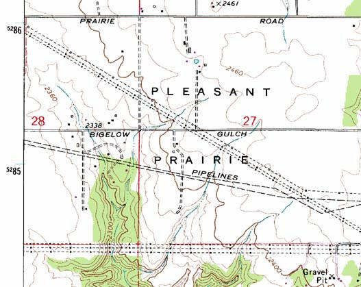
- For the USA, some of the USGS topo maps contain printed representations
of the locations of transmission lines (but not distribution) as you can see
the following USGS DRG. The pattern is dash-dash-dash-dash-dot, with solid dots indicating non-specific
locations of tower structures and hollow dots (small squares) indicating specific
locations of tower structures:
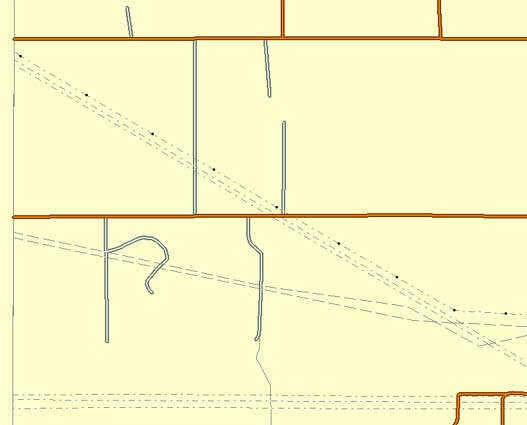
- This information is encoded into USGS DLG (described on the page
Vector Data Sources). The lines are present in the DLG layer "MTF" - "Miscellaneous Transportation
Features". Vectors indicate lines, and special nodes indicate specific tower locations
as in the following DLG rendering:
- A great deal of information is absent - tower type, number of conductors
etc. so that would have to be filled in from observation or other sources.
The data is also not necessarily current; most DRG/DLG date back to the
1970s, although reportedly few long-distance transmission lines have been built
since that time. However, in theory, if one put all the DLGs together, and stitched the topology,
that would produce a free, precisely georeferenced map of every major transmission
line in the USA.
Data Sources: International
- Transmission lines frequently appear on topo maps of all countries, from
diverse source, roughly similar to USGS DRGs.
- See Notes on OpenStreetMap for
the information encoded there (only Transmission, not Distribution)
Software Tools
-
 The VTP software supports procedural
construction of transmission line geometry (towers, catenaries)
The VTP software supports procedural
construction of transmission line geometry (towers, catenaries)
-
The capability is implemented in the vtlib library and exposed in the
Enviro application, along
with a few transmission tower models in the distribution.
-
Terra Vista and other similar high-end scene-creation tools can create
3D powerlines
-
CityScape (high-end scene-creation
tool) has a sophisticated, realtime
Power Line Tool with adjustable cable radius, sag, color, etc.
They were bought by Navteq in 2010; not yet clear what became of the
software.
Models of Power Structures
-
 Transmission
and distribution involve a very large number of different kinds of
transformers, towers, pole and wires, which are a prominent part of the
landscape in most industrialized countries. It is important to model
them.
Transmission
and distribution involve a very large number of different kinds of
transformers, towers, pole and wires, which are a prominent part of the
landscape in most industrialized countries. It is important to model
them.
- The 3D Warehouse has some models (e.g. search there for
electrical+tower) although, as usual, quality is very inconsistent.
- Wikipedia
transmission tower shows some common tower types missing from
OpenStreetMap, like the "tubular steel".
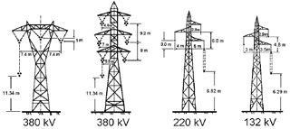
- Some documents exist for the structure and dimensions of towers
Power Data Statistics
- prominent company: RDI, Resource Data International (now owned by
Platts?)
- press releases like "Resource Data International Wins Grand Prize for Electric
Power System Map"
- PowerMAP spatial products suite
- "The heart of RDI’s business
are the comprehensive energy industry database/information systems:
POWERdat,
COALdat, and
GASdat, Covering the electric power, coal,
and natural gas markets."