- the tetrakishexahedron (vrml), basically a cube with its faces split into 4 right triangles, though it could also be thought of as a tetrahedron with each face split into 6 equal right triangles
- however, the triangles do not remain perfect right triangles after the first subdivision

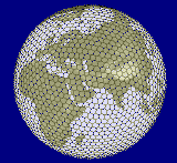
- space simulator for the real planets of the solar system
- has paging and CLOD for the planet elevations and textures!
- he describes: "I have multiple-level texture and elevation blocks. The bottom level is 256x128, after that all tiles are 254x254 + a 1 pixel border. I use separate passes for the color and bumpmapping, which are loaded/generated in a background thread. Mapping is cylindrical, and all tiles are optional (you can leave out high-detail tiles at the poles, for instance)."
- "The algorithm is ROAM with a octahedron mesh. The vertex coordinates are generated from the texture coordinates. The first 5 or so levels are precomputed in a 128KB tree. Vertex coords are float, tex coords are integer."
 T.
Gerstner. Multiresolution Compression and Visualization of Global Topographic
Data (.pdf)
T.
Gerstner. Multiresolution Compression and Visualization of Global Topographic
Data (.pdf)- academic paper describing a ROAM-like tessellation of the globe based on regular geographic coordinates
- oceans are depressed to preserve coastlines
- a global error values allows decimation (compression) of the whole dataset before runtime, the tree structure allows high-resolution insets (their example uses the city of Bonn)
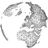
- article describing a simple extension of ROAM to a spherical set of triangles
- Sean chose to use a triangulated cube as his starting point, but it should work as well, or better, to use any polyhedron with more faces
- has notes online describing their terrain engine:
- "The renderer is based on Thatcher Ulrich's adaptive LOD terrain
renderer featured in Gamasutra, with the following changes:
- its wrapped around a sphere
- uses double buffered vertex buffers, and reuses shared vertices when possible
- other extensions, look for "Thatcher" under "Release Notes" for full description
- a closed-source "space shooter" which includes a spherical LOD implementation, lightly described in the thesis An interactive rendering system for real-scale planets combining static with procedural data by Matthias Dondorff, 2008
- "a quadtree layout of regular shaped quadratic meshes [..] capable to generate everything on the fly, best for procedural generated planetary bodies, but it is capable for real planets too."

- Based on an icosahedron with recursive subdivision
- Claims to efficiently page so that only a few MB are ever in memory
- The described algorithm is a lot like spherical ROAM, with splitting priorities and neighbor criteria for LODs
- In 2007, they published an SDK (ovPlanet) of their planetary terrain engine, closed-source but free for non-commercial use.
- A planetary rendering demo (closed source) which shows spherical LOD, bump mapping, noise detail texture, atmospheric glow. Demo datasets of Mars and Earth.
- Apparently last updated in 2003, no current contact for author.