Virtual Terrain Locations - Asia
< back up to International
Parts of the world will become virtualized as time and people arise to tackle
them. If you are working on any particular location and are willing to be
listed here, please let us know!
By Country
- Afghanistan
- Cambodia
- There are 1:100,000 scanned topo-sheets covering all of Cambodia at
Southeast Asian Topographic
Map Databases, CSEAS, Kyoto University, however, there is a
complicated request process involving filling out a paper form in order
to get online access to a small number of tiles with limited use
conditions
- China
- India
- Overall, India is yet another country whose government treats map
data as sensitive, so there is no ready access.
- In 2005-2008, CRIT Mumbai worked on the
evolving Mumbai Free Map
and has the Mumbai Map
Archive, a series of free high-resolution scanned maps and satellite
imagery of Mumbai City, Suburbs, and the Metropolitan Region. The
mumbai.freemap.in site is gone. What
became of it?
- OSM Wiki
Mumbai has some indication that they tried to roll the Free
Map into OSM.
- IIT Kanpur is a prominent tech
school with a LIDAR department, main person is
Dr. Lohani
- They did an aerial LIDAR scan of the school area, and made a
derived "3D Virtual Model of IITK", but unfortunately it's only
publicly visible as a video on
youtube..
- There is a related software
Geokno
LASViewer with a sample dataset (which isn't of the IITK campus)
- According to a 2013 article in the Times of India,
Ranchi to be mapped in 3D
- Jharkhand aims to be the third state after Delhi and Andhra
Pradesh to have 3D map of major cities.
- The 3D map of Delhi is being prepared by Survey of India and
will cost around Rs 120 crore (~$22 million US)
- They will "have every detail including location of
buildings, water and sewerage line, electric cable, roads and
by-lanes".
- LeadDog Consulting
commercially licenses City Street data for some Indian cities at 1:7,500
scale, and Major Roads and Highways for the whole country at 1:250,000
scale.
- UV animation (2007-?) is/was a team led by Guruprassad T.N
providing model services for building 3D cities. The 3D warehouse
showed
many of their models. They had a project called
ModelMyIndia with "A mission to build India in 3D. It is a
virtual model of every city, buildings, structures, etc."
- Contact: Dr. M. R. Nayak, mrnayak@today.com.au, Dy.
Director & Advisor, Enabling Systems, National Institute of Oceanography
(CSIR, India). His interest: modeling the coastal Indian Ocean (Arabian Sea, Bay
of Bengal and the Northern Indian Ocean)
- Iran
- commercial data:
Iran page at East View
Geospatial has 30m DEM for 3 small areas
- NGDIR (National
Geoscience Database of Iran) has some free downloads, but they
are mostly just low-resolution un-georeferenced maps and images
- NCC (National
Cartographic Center) has basically nothing online
- reportedly as of 2004: During the last 2 decades NCC
has tried to develop the whole basemap and topographic map of Iran
(scale=1:25000). It is almost completed. They used 1:4000 aerial photos.
- Japan
- Kazakhstan
- the Virtual Heritage Lab
of CNR-ITABC has built interactive virtual models of an archaeological
site of Kazakhstan
- Korea
- a commercial data source exists:
- 1 second interval DEM (~30m), covers south and north Korea
- divided into 240 areas, each 15 by 15 minutes
- it is derived from a contour map (1:50,000 scale) via TIN
- for more information, email
Hoseong Kim (김호성) of More Technologies Inc.
- there is a beautiful cloud-free
true color 250m image in the MODIS gallery
- another commercial source for DEM and vector data:
North Korea Geospatial Data from East View Geospatial
-
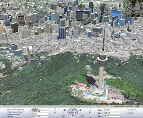
ZDNet press release on May 4th, 2007: "...successful utilization
of 3D technology in its development of Urban Planning Information
System. Seoul Metropolitan government used high quality 3D
Geospatial database developed from a 1 meter digital terrain model ,
texturing 10cm aerial imagery covering 605 square km (1567 square
mile), about one million box-shape simple model for general
buildings and 1200 accurate model by using actual picture of the
major landmarks.
-
- Korean company
Woodai Cals Ltd. developed the system technology for the
Seoul project, and reportedly has clients in other countries as
well.
- Kyrgyzstan
- Laos
- There are 1:100,000 scanned topo-sheets covering all of Laos at
Southeast Asian Topographic
Map Databases, CSEAS, Kyoto University, however, there is a
complicated request process involving filling out a paper form in order
to get online access to a small number of tiles with limited use
conditions
- Malaysia
- report: "in Malaysia, there is no DEM yet, all are in DXF
contour line, and mostly digitized from 1:25000 hardcopy, the price
about RM800 per sheet."
- Myanmar
- Orthocoverage
Downloads includes a free sample of good data (15m greyscale image,
15m elevation) for a small area in Myanmar
- Philippines
- Russia
- There exists a vast set of Russian military topography maps
which can be used to generate 1:200K DEMs
- contact Harri Lilja
has done VTP modeling of city area of Beslan, located in North Ossetia,
near Chechnyan border
- Taiwan
- report: "DTM ASCII exists at 40m grid spacing, but it is
strictly licensed."
- update 2003.08: "Taiwan has a pretty complete
coverage of DEM, aerial photographs, and satellite images. They are
all available at reasonable cost. There are also a variety of GIS
layer data, but they are scattered in different agencies and
organizations."
- Thailand
- GISTDA (geodata agency) deals
with satellite imagery, reselling it for mysteriously high prices
- Tibet
- Vietnam
- Reported in 2006: "Geodata of Vietnam is mainly occupied by
Government Agencies. That's why so little public geo-Information is on
Internet. Vietnam is on the way to become an e-Government, at that time
I think everything is opened."
- Center for Information
and Archives of Geology has mostly geological data, browsable but
not downloadable
- CIREN: The Portal of Natural
Resources and Environment Information may lead to some geodata, but
the site is entirely in Vietnamese so it is difficult for me to tell
- There are 1:100,000 scanned topo-sheets covering all of Vietnam at
Southeast Asian Topographic
Map Databases, CSEAS, Kyoto University, however, there is a
complicated request process involving filling out a paper form in order
to get online access to a small number of tiles with limited use
conditions
The Himalaya
- The best known elevation data for the Himalaya are the improved SRTM tiles
available from Jonathan de Ferranti's
Viewfinder Panoramas site
- Not geodata, but a
stunning QTVR from
the peak of Everest (border of Tibet and Nepal) provides a good
reference image for what visualization software can aim to achieve (as well
as a great example of how to properly put a QTVR image on a webpage without
constraining its width.)