Romania
< back up to Europe
Data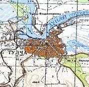
- earth.unibuc.ro,
hosted by the University of Bucureşti, is a great
starting place (Romanian language) for Romanian geodata: articles,
tutorials, resources, and much more
- As of 2010, the site hosts a WMS server with many imagery layers,
including:
- Historical Autrian topo maps
- Soviet maps at 1:100,000 scale reprojected to Stereo70
- Hill-shaded SRTM, rasterized vector data for many cities, and more
Other Sources
- Some of the major commercial vendors include:
- Geo Strategies, main
data page is
GIS & Map Data for Romania
- their DEM (DTM)
is available in a 100m grid
- Geosystems Romania, also a
reseller for ESRI, LizardTech, Trimble, EuroMap products. The are
reported to sell vector basemap including roads, railways, etc.
- InteliGIS
- NACLR - ANCPI (National Agency
for Cadastre and Real Estate)
- they sell high-resolution aerial photos, which are available for
approximately 10% of Romania, and the price is around 40$/tile
- each tile is 5040x5040 pixels, 0.5 meter resolution, so that's
2.5x2.5 km
- detail is great and accuracy is reportedly extremely good, but
color quality is poor: the images look nearly desaturated
- there are a number of free local datasets, but not yet any kind of
directory for them, so they can only be located through word of mouth
- contact: Vasile Craciunescu [vasile33@yahoo.com]
is the guy to ask about all sorts of data, especially DEMs
-
 free
ASTER DEMs provide some spotty coverage of the country
free
ASTER DEMs provide some spotty coverage of the country
- LandSat imagery:
GLCF ESDI
now has LandSat ETM+ scenes for most of the country
Law
- reportedly, there is a very old law on the books in Romania which says
that
all detailed maps of the country (1:5000 or better?) are national
secrets and forbidden to possess - while bizarre, it does not apply to
modern data such as vectors, only to things which resemble a conventional
map
- also reported: "There are other laws about aerial photography. Any kind
of photo or video obtained from the air (flying vehicle) must have written
approval by the Ministry of Defense (MApN) at least 2 weeks prior. Those who
take pictures/videos without approval risk heavy fines and possibly jail.
Pilots of aircraft from which such photo/video was taken risk the same, and
also having their pilot's license revoked. (regardless of their
implication)."
GPS
-
 Proiectul
România Digital (PRD)
Proiectul
România Digital (PRD)
- The Digital Romania Project, site in Romanian only)
- The project plans to provide a central site which will gather
together as much as possible of the data existing for the country, then
provide it in a form usable by Garmin GPS units, so that there is a
basemap to make the GPS devices useful.
Bucureşti
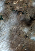
- Some aerial images of Bucureşti appeared
on the net after a promotional blimp was flown over the city in June 2004
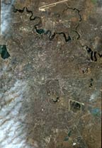
- There is also a satellite photo of Bucharest (resolution 1m/pixel,
11448x16624, 200MB JPEG) which is floating around the internet, although it
is assumed to be not in the public domain. I found a copy and made a
derived version with most of the clouds and cloud shadows fixed. Thumbnails
shown at right, but full file isn't online here because of the unknown
rights.
Constanţa
- The SpaceEyes3D commercial terrain
tool has a number of free demonstration datasets, which includes a model of
Constanţa's city center. It includes an orthophoto, road centerlines, and
extruded footprints for the large buildings. Data source is
www.geoimage.fr
Braşov
- vrbrasov.ro hosts an
interactive map and stunning QTVR images of Braşov
Projections
- there are a few unusual projections often encountered with Romanian data
- Stereo 70 ("stereo şaptezeci")
- "Hristow" Oblique Stereographic, units are meters
- Ф0 = 46° North and λ0 = 25° East of Greenwich
- False Easting = False Northing = 500 km
- m0 = 0.999750
- uses the "Dealul Piscului 1970" Datum (Krassowsky 1940 ellipsoid)
- As a projection file: stereo70.prj
- Gauss-Kruger ("GK")
- GK is a German ancestor of UTM; like UTM, it is a set of Transverse
Mercator zones
- Zone 4 or 5 was used for Romania
- Zone 4 is: False Easting = 4500000, False Northing = 0,
Central_Meridian = 21, Scale_Factor = 1, Latitude of Origin = 0
- Pulkovo 1942 datum (Krasovsky 1940 ellipsoid)
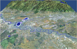
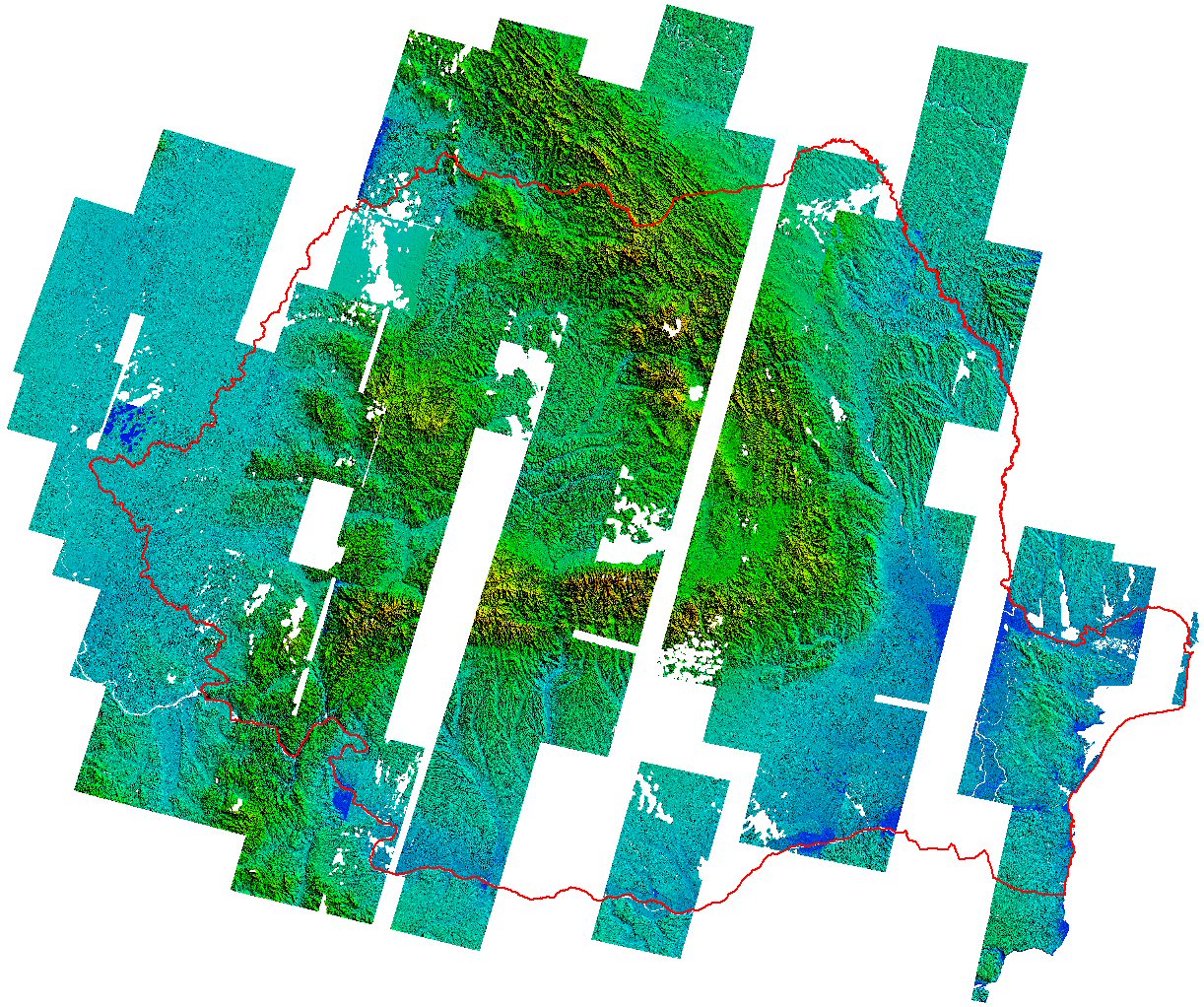
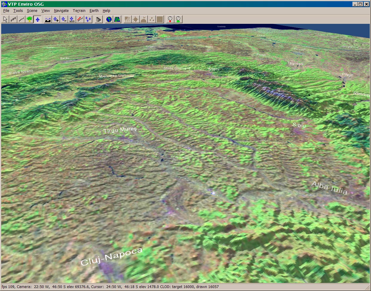
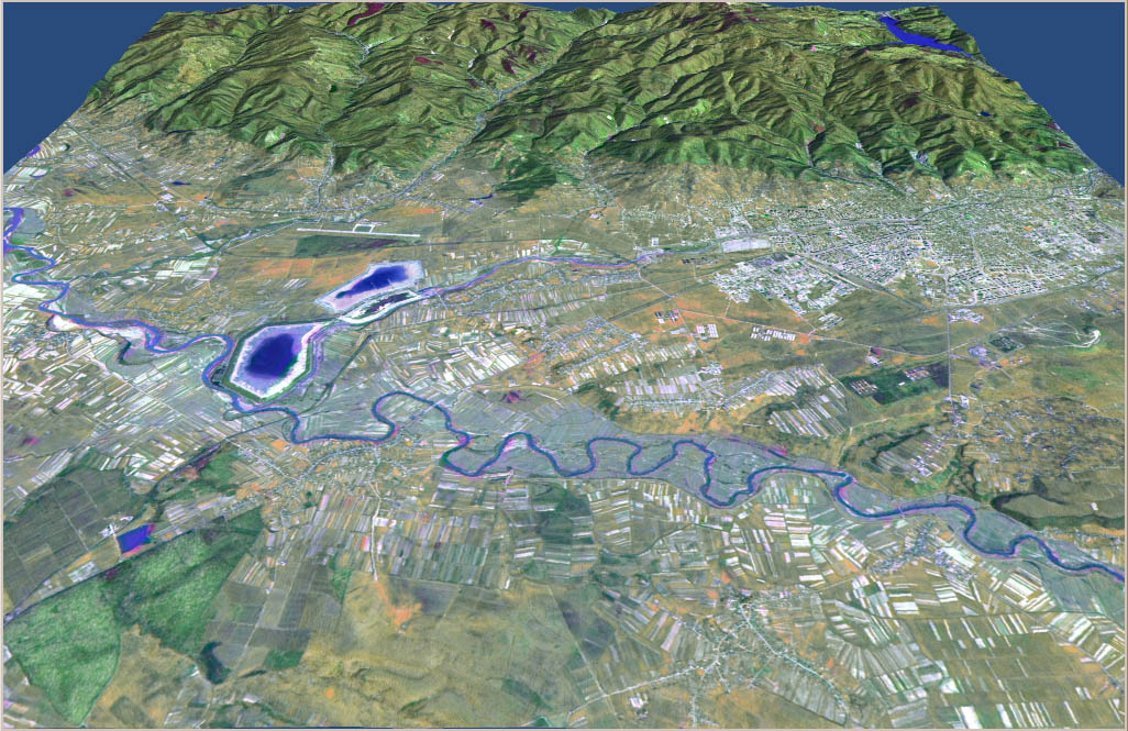
VTP Scenery
- 2003.06, created 2 VTP scenes: all of Romania, and the Giurgiu-Bucureşti
area
- from GLOBE elevation and JPL LandSat7 false-color from their WMS
- put a snapshot of Giurgiu-Bucureşti on the
Screenshots page
- a couple snapshots of the whole country terrain:
-
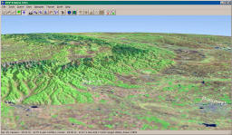
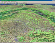
- as of 2003.08.19, there are 37 non-bouncing VTP recipients in Romania
-
 Braşov
area: Geo (24.64, 45.14), (1.47, 1.03) is a 120*120 km area, suitable for a
4k*4k texture of 30m LandSat
Braşov
area: Geo (24.64, 45.14), (1.47, 1.03) is a 120*120 km area, suitable for a
4k*4k texture of 30m LandSat
- City of Baia Mare and environs, which is now in the
BT repository
- UTM zone 34, elevation 17.5 km square
- elevation of
size 2049 (8.5 meter grid interpolated from local contours)
- imagery
2048*2048 from false-color satellite image
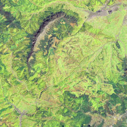
Misc. notes on Romanian national parks and protected areas
- National
Park Piatra Craiului
-
 had an online park map server around 2003-4 (?) at
http://map.pcrai.ro/
had an online park map server around 2003-4 (?) at
http://map.pcrai.ro/
- extents are given as 45°22'03" şi 45°35'11"
latitudine şi 25°07'38" şi 25°23'18" longitudine
- extracted LS image at (25.127222, 45.367500), (0.261111, 0.218888)
- this is roughly 20 * 24 km
- at 30m resolution, LS images don't need to be larger than 678 x 814
for an area that size - hence
parcul_pc_v3_1024.jpg
(right)
-
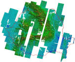
CLCP (large carnivore project) has
a base in Zarneşti, that town visible in the upper right of the image
- the IT folks at the park had some elevation data at some point, from
their animated GIF of a shaded rendering, low resolution but looks
better than 1km, probably at least a 500m grid
- parks extents shown in Encarta (8 parks)
- National Park
Retezat, Cheile Nerei-Beuşnita, Pietrosul
Mare, Cornedei-Ciungii Balasinii
- in Danube basin: Sfîntu Gheorghe-Palade-Perisor,
Pădurea Caraorman, Roşca-Buhaiova, Pădurea Letea
- not in Encarta:
- national agency MMGA (Ministerul
Mediului şi Gospodarii Apelor)
- At one point, it provided some SHP files
for all 18 official parks, including park boundaries - can't find on the
site as of 2011
- coordinate system is Gauss-Kruger zone 4 or 5, Pulkovo 1942 datum
- some NGOs which might be able to point to data
- a commonly reported factoid:
- "Romania has 13 national parks, 371 geologic monuments, 46
scientific reserves, and 18 protected landscapes. All together there are
586 protected areas"
- however, nowhere is a list of these 586
- a Council of Europe page from 2002 even claims "827 protected areas,
covering 5.2% of the country's area" (!!)
-
Protected Areas in Romania according to IUCN norms lists:
- 43 Scientific reserves, 12 National Parks, 135 Natural monuments,
375 Nature reserves, 18 Protected Landscapes, 3 Biosphere Reserve, 1
World Natural Heritage Site, 1 Ramsar
site
- nature reserves broken down into 122 botany reserves, 15
zoological, 65 geological, 58 speological, 52 paleontological, 51
forestry, 155 mixed
- that makes 588 total
-
 The
UNEP-WCMC has the
WDPA (World Database on Protected
Areas)
The
UNEP-WCMC has the
WDPA (World Database on Protected
Areas)
- as of 2003.08.17, it listed:
- 157 total: 1 Biosphere Reserve, 1 Botanical Reserve, 1 Flora
Reserve, 11 Forest Reserve, 15 National Park, 2 Natural Monument,
120 Nature Reserve, 6 Scenic Reserve
- of these, 53 have a map coordinate (single point)
- as of 2005.04.14, it lists:
- 184 total: 1 Botanical Reserve, 1 Flora Reserve, 14 Forest
Reserve, 17 National Park, 2 Natural Monument, 1 Nature Park, 142
Nature Reserve, 6 Scenic Reserve
- it's hard to tell with the current website how many of these
have coordinates
- there don't appear to be any polygonal areas for Romania, only
points
- there are at least 20 kinds of "protected area"
 free
ASTER DEMs provide some spotty coverage of the country
free
ASTER DEMs provide some spotty coverage of the country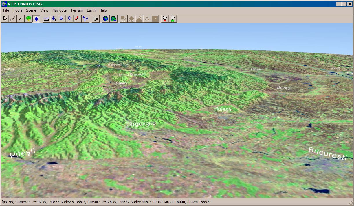
 Braşov
area: Geo (24.64, 45.14), (1.47, 1.03) is a 120*120 km area, suitable for a
4k*4k texture of 30m LandSat
Braşov
area: Geo (24.64, 45.14), (1.47, 1.03) is a 120*120 km area, suitable for a
4k*4k texture of 30m LandSat had an online park map server around 2003-4 (?) at
http://map.pcrai.ro/
had an online park map server around 2003-4 (?) at
http://map.pcrai.ro/ The
UNEP-WCMC has the
WDPA (World Database on Protected
Areas)
The
UNEP-WCMC has the
WDPA (World Database on Protected
Areas)