United Kingdom
< back up to Europe
Data Sources
- The main government site is
Ordnance Survey Maps - Britain's
National Mapping Agency
- their primary digital data products are in a collection called the
OS MasterMap
- feature data in the MasterMap is encoded as GML 2.1.2
- Before 2010, all of their data was expensive and highly restricted
in usage
- For example, before you could access any data, you had to explain "length of
time you wish to use the data and the number of terminals on which data will
be used". Reportedly, a 3-year license to all features for the country cost
£500,000 + VAT(!)
-
As of 2010, UKOS data
became more open, this is now on on the
OS OpenData page
- OS scanned topo maps (e.g.
1:10k Scale Raster and
1:25k Scale Raster)
- they look significantly different than USGS
DRGs - houses are beige and individually
sized, property extents often appear, and small roads appear with width
rather than as lines
- There are services such as EDINA
Digimap, Landmap which provide access to OS and other geospatial data,
for specific educational institutions only.
- EDINA ShareGeo Open
- A repository for sharing data openly; as of March 2011 it seems to
contain primarily common free datasets (OSM, SRTM, VMAP, etc.) reprocessed
into ESRI formats.
- Most of the data is abstract (boundaries, postcode areas, POI, etc.)
- Getmapping is the main
commercial source of digital aerial photo data.
- It appears to be the only significant source of non-OS geodata for
the UK, aside from global datasets like SRTM or OSM.
- old-maps.co.uk
provides browse-only access to UK digital historical maps, generally 19th
century
Elevation Data
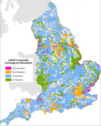
- Environment
Agency LIDAR for most of England, free and easy to download.
- Most of the data is 1m resolution; some is 2m, 50cm or 25cm.
- A
blog entry in October 2015 describes the dataset and their intention
to put all 10 TB of it online
- DEM from the Ordnance Survey
- the old standard product is 50m resolution, standard tile size is 20km
(401x401 points)
- (usage of) the data costs ~US$70 per 20km tile
- first year license fee for the whole of the UK was ~US$30,000, with 10%
annual maintenance fee
- newer product, 10m DEM, is called
Land-Form PROFILE
- standard tile size is 5km
- (1-year usage of) the data for the whole country costs £56,250 plus VAT
(!) or £25 - £100 per tile per year for smaller areas
- The even newer OS OpenData site has
Land-Form PANORAMA, which is free to
download
- "Spot heights, breaklines, coastline, lakes, ridges and formlines
with a 10 m contour interval. Also available as a gridded DTM with 50
m post spacing"
- In Ascii Grid and NTF formats, it is a grid of 812 files in 55
folders, each a 401x401 grid (at 50m spacing)
- Another 50m DEM is
OS Terrain 50; the heights are to 0.1 m, compared with 1 m for the
older Land-Form PANORAMA data.
-
NEXTMap Britain Height Data
- 10m/5m DEM of the whole country
- it was produced using IFSAR, so it will have issue with ground clutter
like trees and buildings
- they provide it in two forms:
- as-is with the clutter, which they call Digital Surface Model (DSM)
- a processed version with an attempt at removing the clutter, called "Bald
Earth"
-
reportedly, "1 km sq. with a 25cm aerial drape comes in at around £165 ($250)
... I believe the terrain data was about £65 of that. Prices drop with
larger amounts."
- cleaned-up SRTM data (~100m) is available from
Geomantics Data Services
- very inexpensive: £20 for each set, or £100 for all 6 sets covering the UK
and Ireland
Projects
-
 Virtual NewcastleGateshead (VNG)
- A joint venture of Northumbria University and the city councils of
Newcastle and Gateshead, to create a model of the urban core
areas of both cities, primarily to assist in urban planning. First
phase of work was 2009-2012.
- Covering 30 km2 as of 2012, with a goal to reach 102 km2.
- Accuracy is claimed as better than "25cm for 70% of points".
- Stored in .dwg, so presumably built on an Autodesk stack.
- A report by
Peter James Morton titled
Virtual City Models: Avoidance of Obsolescence uses the VNG project as
a detailed case study.
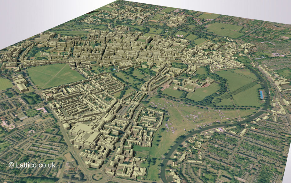
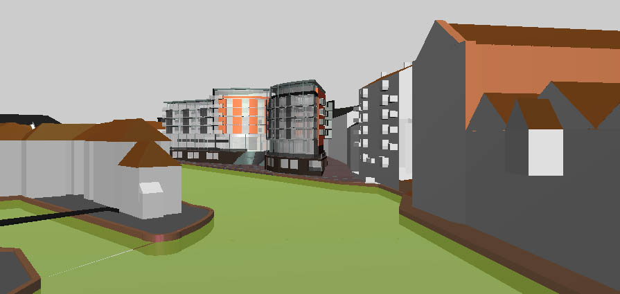
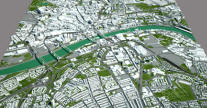
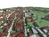
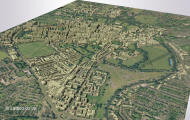
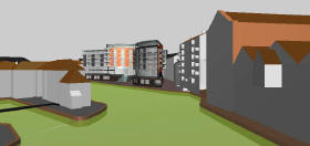
- Lattico Ltd. is working on 3D
digital modeling project of the city of Cambridge, as well as some other UK
cities.
- They work heavily in the CAD environment with an architectural emphasis,
using photogrammetry to collect data and working with the DWG format.
- Images from their Cambridge model:
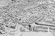
- Leeds 3D - Holbeck Urban
Village
 (2006)
- also called '3D CityScape', it was a project of the city of Leeds and GIS
firm AMT3D to digitize a large section of the city that was being redeveloped
- An earlier Leeds project involved VRML scenes of
now and
future (no longer online) for a new
building in an area known as "The Calls"
- A laser scanner will be used to capture the target building’s 3D geometric
structure along with an integrated digital camera (mounted on the top of the
scanner) to provide photographic texture.
- They claim 'The 3D model can be viewed directly via a web browser or
combined with CAD data to provide ‘in-context’ visualizations. A new GUI is
available based on 3D games technology for an interactive on-screen method
of navigating in and around the CityScapes model." This refers to the
Quest3D architectural visualization engine.
- As of February 2006 there were screenshots and small videos, but not anything interactive or downloadable from the AMT3D or
Holbeck Urban Village
websites.
-
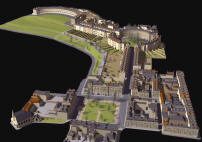 Bath
Model (1991-)
Bath
Model (1991-)
- In 1991 CASA received a grant from J Sainsbury plc to construct a 3D model
of Bath. This project was supported by Bath City Council and since its
completion the model has been used to test the visual impact of a number of
proposed developments on the city.
- The model comprises over 150 urban blocks
- You can buy (license) individual blocks, although they are not necessarily
updated since the mid-90s
 the
Norfolk Coast has been the subject of modeling for visualization in coastal
zone management by Simon Jude of
the UEA School of Environmental
Sciences (University of East Anglia)
the
Norfolk Coast has been the subject of modeling for visualization in coastal
zone management by Simon Jude of
the UEA School of Environmental
Sciences (University of East Anglia)
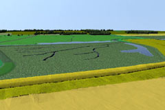
- the Isle of Man Agricultural Soils Group
has done some modelling of the island
- with soil and land use maps draped
over a DEM:

-
Virtual Stonehenge: A LiDAR Survey
Flythrough (vimeo video, Nov. 2007)
- Shows the landscape around Stonehenge based on LIDAR from the UK Environment Agency.
- By using LIDAR instead of surveys or aerials, features such as
well-preserved barrows and subtle earthworks of prehistoric field
systems are clearly visible.
- A project of Wessex Archaeology,
described on their blog entry
The Stonehenge Landscape in 3D

Services
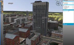
- Service company Skape, based in
Leicester and launched in 2010, "provides presentational 3D city and mapping
data as well as high accuracy building data", focusing on the UK.
- They claim to be the first to provide "advanced imagery of 3D
heighted buildings of the UK's major cities."
- They appear to have their own proprietary runtime software, but it's
not clear from their site.
- Developed by Infoterra, a
GIS and imagery vendor.
London-specific
-
 Virtual
London projects at
CASA/UCL
Virtual
London projects at
CASA/UCL
- For many years, there was an ambitious goal to build a huge, interactive
London model
- In 2005, article Virtual London unveils to fans, GIS Pro magazine described that a small
section was done
- Two key requirements of the project: that the modelling should not have to
rely on detailed architectural drawings, and that the material should reach
as wide an audience as possible (i.e. via the Internet).
- They are using ESRI ArcScene to do the modelling
- 3% of the 45,000 building blocks had been photogrammetrically rendered
(mainly key buildings), photo-realistic textured areas is even less at
around 25 buildings plus 20 landmarks
- funding came from the
Greater London Authority
and British Telecom
- a side project was trying to get the model running in the Far Cry
game engine
- related academic paper/website: Andrew Hudson-Smith,
Digitally Distributed Urban Environments: The Prospects for Online Planning
(or as a single pdf) -
Chapter 9 in the PDF talk about Virtual London
 Google
Earth
Google
Earth
- Aside from the many contributors to general UK models for Google
Earth, there are some London-specific efforts.
- January 2011:
The great work behind the London 3D Project (building models for
Google Earth); site is
London3Dproject
- It's good to hear that they are "making a point to try to tackle a
lot of the 'boring' buildings that people otherwise might not model"
- Zmapping (regular
site / flash site)
- since 2005, they have been producing 3D models of parts of London
- they use photogrametry from aerial photos "from a height of around 534
meters, captured during the winter so that none of the street detail is
obscured by trees"
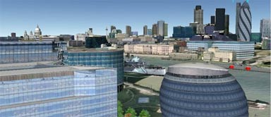
-
 Vertex Modelling's Wide
Area 3D Model of London
Vertex Modelling's Wide
Area 3D Model of London
- commercial model, "supplied as standard in a solid CAD format not 3D
faces, this allows façade features such as window and door detail to be
simply added. Models can be sliced into floors or extensions added with
speed and simplicity."
- "consistent high positional accuracy of 15cm"
- older commercial model in 2006:
3D-London™:
ImageCat's 3DCity™ Model for the City of London
- Detailed structural model of the more than
1,000 buildings, attributes include building height, number of
stories, footprint area and location, made from DigitalGlobe QuickGlobe
imagery using software called MIHEA (Mono-Image Height Extraction Algorithm)
- Claims to be 'compatible with Google Earth,
ESRI software and other common GIS applications'
- As of 2009, the
ImageCat website no longer
mentions this model.
- Street sensation! - The
liveliest streets in London
- store-front images of over 2,500 shops,
bars and restaurants, which would be great to map into a virtual scene
-
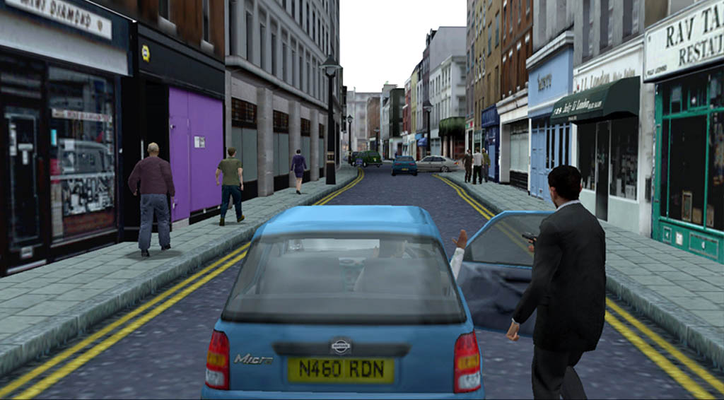
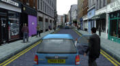 the
console title The Getaway (2003)
the
console title The Getaway (2003)
- included some of the most impressive city modeling to date, apparently the
result of several years of hand-modeling by a large team of modelers,
resulting in a reproduction of a large part of London, yet fitting within
the limitations of the Playstation2