State of New York
< back up to USA
- New York State GIS Clearinghouse
- some layers are free
- available for the whole state: DRG, NLCD
- there are beautiful color Orthoimagery for most the western and
central counties (but not NYC), and false-color (CIR) image for nearly
the whole state, excepting parts of NYC
- others layers are expensive, but free to member of the NY State GIS
Data Sharing Cooperative
- 1:100k Hydro, public roads in ArcInfo format
- from May 2002 to November 2003, a lot of the data was put offline due
to paranoia, including NYC DRGs, but it appears that a few years later,
it was (nearly)
all back up
- LIDAR
Coverage in NY State; their goal is a 2m DEM; as of 2013, it does
not contain New York City
- City of Ithaca
- Attractive for visualization because of amazingly complete and public
GIS data for the whole city: includes parcel boundaries, building footprints,
road widths and curbs, sidewalks, driveways, even every individual planted
tree
- For years it was at www.ithacamaps.org, but as of 2011 that
is gone and the data is probably somewhere inside CUGIR:
- Cornell University Geospatial
Data Information Repository (CUGIR)
- Hosts a number of public vector datasets for New York State, mostly
Census data
- State Plane
- The New York State Plane coordinate system has 4 zones: East (3101),
Central (3102), West (3103), and Long Island (3104).
- Manhattan is in 3104: LCC, SP1 41:02, SP2 40:40, Lat 40:10, CM -74,
false easting 300000m, false northing 0
- ...but since too many people are still using feet, that's actually a
false easting of 984250 feet (U.S. Survey Feet)
- Hudson
River Estuary Benthic Mapper
- a program in progress to gather high-res detail on the bathymetry of
the Hudson River
- they have a map viewer online, but no public data
New York City (NYC)
Regional Data Sources
- GIS Data Depot -
New York does have most of the basic USGS layers
- 1 meter color DOQ, which are unfortunately deeply flawed by building
parallax and dark shadows
- DLGs are very spotty, e.g. completely lacking in transportation layers
(strange)
- DRGs are available, although color scheme is not well matched across
quads
- 10m DEMs are fairly good, although an edge discrepancy puts a significant
5m wall in Manhattan
- CUGIR - Cornell University
Geospatial Data Information Repository
Base Map
- NYCMap (pronounced "nice map") is the new, master New York City
Base Map (2001-)
- it is produced by DoITT
(the NYC Dept. of Information Technology and Telecommunications)
- specifically, the GIS Sub-Committee of the Technology Steering Committee
- main person: Alan Leidner, director of city-wide GIS, DoITT
- very involved: geography professor Sean Ahearn at SUNY's
Hunter College's Geography Dept.
- HydroQual, Inc. seems to been
involved as well
- strangely, the DoITT website now has no mention of the existence
of NYCMap
- NYCMap is not available to the public! it is licensed under
strict terms to organizations deemed worthy
-
New York City’s New Base Map: The Holy Grail? a good article
(July 2001) giving the historical background and creation process leading up
to the NYCMap, esp. how bad it used to be before a unified base map
Aerial Imagery
- bluesky sells NYC aerials at
25cm resolution
- gathered in summer 2003, covering all 5 boroughs
- claims use of GPS ground control and 80% exposure overlap makes it fully
orthorectified
- Reportedly: "On the
Getmapping USA site, you can actually purchase and download the Bluesky
imagery. The search function is (difficult to use), but once you find what
you are looking for the imagery is quite nice. It costs about $45 for a
0.3mile x 0.3mile data set, and they email it to you immediately."
- Is this the exact same imagery that was licensed by NYC DoITT in 2004, which
is available to all city agencies and partners with access to the NYC intranet?
Or did DoITT have their own imagery flown?
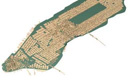
City Models / Building Models
- Planet9 has a model of some parts
of Manhattan
- they sell/license it as part of their
virtual cities product line, but there are no details about it on their
site
- Environmental Simulation Center
(ESC)
- began a model of lower Manhattan back in 1993, very cutting-edge, queryable
with real estate attributes
- it has grown slowly over the years, on an as-needed basis, with hand-modelled
buildings
- they still license their model today, though their emphasis is on solutions
rather than data
- Analytical Surveys Inc. (ASI) and Sanborn
- reportedly produced a 3D model of lower Manhattan for the
NYC DEP, mentioned in
this article,
though ASI's site doesn't mention it
- the paper
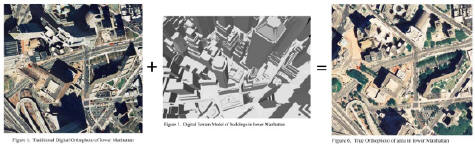
Digital Orthophotography
in New York City by Anthony Thorpe of Sanborn also describes the creation
of a fully 3D model for NYC DEP, which he says resulted from a 1997 contract
between DEP and Sanborn - presumably this is the same project, with Sanborn
and ASI working together
- the paper includes a snapshot of a 'virtual reality model' attributed
to 'METROScape'
-
- METROScape is apparently terminology of ASIT (ASI Technologies), based
in Colorado Springs, CO, a customer service center of ASI, closely linked
to Sanborn
- CommunityCartography (ComCarto)
- sells many layers for NYC, some of which can reportedly be used to produce
3D building models. although its unclear which of their products contains
this data
- ComCarto is one of the NYCMap licensees, and sells maps/services based
on it
- their "clients" page credits "HydroQual's H4D program"
with an impressive looking 3D flythrough, including textured buildings,
but there is no mention on the HydroQual site of this or "H4D"
- as of May 2004, their site apparently no longer mentions a 3D NYC model
- Marco Zgraggen is a Swiss city modeler with an ambitious
project to model NYC in 2005
- building mass-models only, no textures or other culture
-
 Nina
Fater's model on 3D CAD Browser.com
Nina
Fater's model on 3D CAD Browser.com
- a surprising 3D Manhattan available in a variety of formats, options
for downloading start at $75
- review of the model, August 2004: "The accuracy
of the model varies. Some areas are just standard blocks without any details,
others are modeled very detailed and realistic. Some Buildings are placed
wrongly, but this could [possibly] be corrected."
- 3dskylines.com (VisionMedia) has
a partial Manhattan model
- "Our Manhattan model covers [....]. The model comes in many 3D
formats including 3D Studio Max, Maya, and others. John Perry, VisionMedia"
- As of 2007, they claim the entire island is finished and available. "Despite
all the complexities, the Manhattan model uses only 500,000 polygons.
Projection is UTM NAD83 ZONE18. Pricing for our models depends on
a tiered structure. The end user price depends on the project and size of
the business."
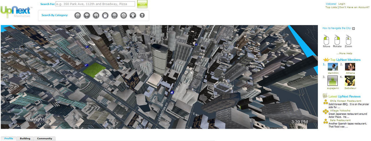
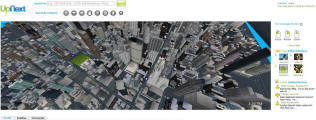
- UpNext 'Manhattan beta'
- Launched in 2007, UpNext is a 'next generation local city guide.'
It uses a Java plugin to show a very fast, simple rendering of nearly every
building in Manhattan, each one clickable to a database of stores, restaurants
etc.
- Rendering appears to be efficient with far clipping, small texture catalog,
blended impostors, culling of buildings immediately around the camera, and
other optimizations.
-
- there is a 3DS model of the Statue of liberty,
available many places online, which appears to be public domain
- Company 39 is a small part of consulting
giant PB
- they did lowermanhattan.info
and do some 3D visualization projects; they have modelled some subway stations,
and 3D models of the subway lines through city
- The NYC Dept. of City Planning has done some visualization stuff, sometimes
utilizing a visualization shop called
Screampoint, which has produced large scale animations for New York City
agencies, including the animations for the proposed rezoning of the Hudson Yards,
which has received a lot of exposure.
- an anonymous industry commentary: "Screampoint
produces some pretty slick materials, primarily 3D Studio animations. While
they have an office in Rockefeller Center, I understand that the labor is
all done in China. In theory they built all this data for the City of New
York under a public contract [..] tried to get their models and textures
for another public project they claimed that the City just purchased the
animations and they retained exclusive ownership of all data produced."
- a group called 3dNY wanted to start a
'Manhattan Project' in 2001 to produce a shared model of the city, but apparently
it never happened. "In 2002 3dNY will launch what may become the
largest online collaborative effort conceived for the international 3d community:
The modeling of Manhattan."
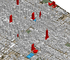
- Urban Data Solutions
- Produced models for 13 cities including NYC, with "approximately
one-meter accuracy"
- Began work on their NYC model back in 1996, targeting applications such
as cell antenna placement
- In 2004 they launched a site MetroBlocks with a web interface
for producing a variety of 2D and 3D "maps" utilizing their 3D
city models
- As some point later, they disappeared
-
Manhattan Timeformations
was an art project (2000)
- involved creating Form*Z models of 726 skyscrapers
in lower Manhattan, and presenting them in a Flash animation
- lead: Brian McGrath, professor of urban design
at Columbia
- 3D digital models were constructed by Parsons School of Design architecture
students Akiko Hattori and Lucy Lai Wong
Historical
-
 The
Mannahatta Project (2007-2009)
The
Mannahatta Project (2007-2009)
- The aim of the Mannahatta Project is to reconstruct the ecology of Manhattan
when Henry Hudson first sailed by in 1609 and compare it to what we know
of the island today.
- Very multidisciplinary - ecology, culture, hydrography, etc.
- A lot of the terrain comes from a detailed analysis of a British Headquarters
Map of 1782.
- The plan is to eventually produce a Virtual Mannahatta 3D website, soundscape
map, and other public educational material.
- To date (2007) they have used ArcView and Visual Nature Studio.
Transportation, Roads and Traffic
-
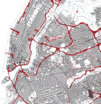 DCPLION
Single Line Street Base Map
DCPLION
Single Line Street Base Map
- contains a single line representation of New York City streets with
address ranges and other information, including street names
- they are single centerline segments - not even polylines
- there is no information on widths, lanes or intersections, so the emphasis
seems to be on address geocoding rather than physical description
- in MapInfo format (TAB or MIF)
- New York Long Island State Plane Coordinate System (NAD83, feet)
- five sets of files, one for each borough, BX= Bronx, BK= Brooklyn, MN=
Manhattan, QN= Queens and SI= Staten Island
- a "segment" is defined as "the uninterrupted portion
of a street or non-street feature between two consecutive cross streets
or non-street features"
- the files display well in Global Mapper and should be loadable with
OGR
-
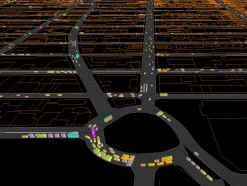 Midtown
Manhattan 11th Ave. Study using
Quadstone Paramics (2004
Midtown
Manhattan 11th Ave. Study using
Quadstone Paramics (2004
- done by Urbitran, a planning/engineering firm
- over 200 signalized intersections in a 200 block area of a highly congested
dense urban grid network stretching from 23rd Street to Central Park and
6th Avenue to the Hudson River
- Urbitran also did many other transportation studies in the NY region
- New York Public Interest Research Group
(NYPIRG)
- had a Community Mapping Assistance Project (CMAP) with a mission to "strengthen
nonprofit organizations by providing affordable access to computer mapping
technologies". Tried to have data, but eventually it went away.
- TIGER - New York is FIPS code 36 061
Subway
- nycsubway.org - New York City Subway
Resources
- browsable 2D maps:
-
 Is
subway route information available in a literal form, not as a abstract schematic
view? Only in some formats:
Is
subway route information available in a literal form, not as a abstract schematic
view? Only in some formats:
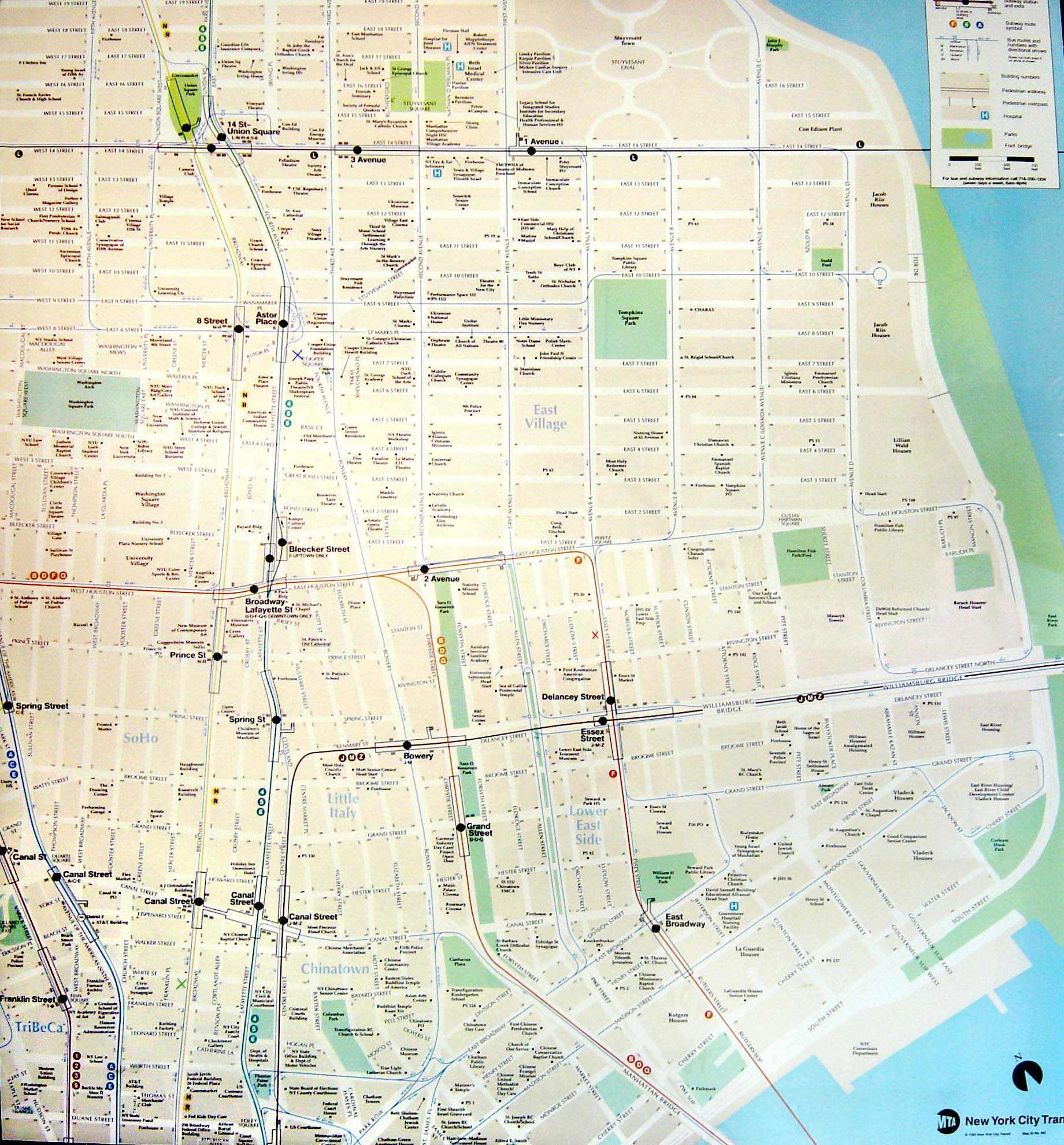
- The MTA produces printed subway maps for parts of Manhattan, which are detailed
and to-scale, although not (directly) available from their website. A
example is this printed scale map of the Lower East Side was
found and scanned (JPEG).
- The MTA subway map website
has a bitmap for the whole system (not to scale) and a PDF (to scale) of lower
Manhattan. Until March 2003 when they removed them, there were also
Manhattan Neighborhood Maps in PDF which cover smaller
areas than the printed wall maps (31 total).
VTP Scenery Development
- created lower Manhattan BT from 10m DEM, imported roads from DLG, building
footprints from NYCMap
- input building attributes from direct observation for around 30 buildings
- snapshots March 2003:
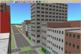
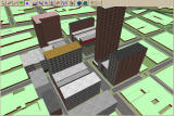
- major issue: for heavy urban environments like this, road and sidewalk widths
are a dominant factor in the appearance of the scene near ground level, but
these properties are not currently well represented
- abstract road information (e.g. number of lanes) is insufficient, needed
are actual widths, paved and sidewalk areas (or better heuristics to guess this
data)
- acquired the DRGs (quads brooklyn, centralpark, jerseycity, weehawken) and
made a drapeable BMP, which is somewhat useful in a cartographic way
Other Data Layers
- NYC
Historic District Maps has bitmaps and DPFs showing where the "historic
districts" are
- NYCEM - New York City Area Consortium
for Earthquake Loss Mitigation ()
- contains many extensive reports done at Princeton and SUNY, with every
possible scenario taking into account building heights, building composition,
soils, zoning and economic valuation, and more.
- they say "this research has collected information about every building
in Manhattan" but doesn't say from where, or anything about the location
or availability of the data
- New York Songlines is a browsable
sort of walking tour with cultural/history layers of the city
- One Day in Midtown Manhattan is not digital data, but an astonishingly
detailed isometric view produced manually by a Japanese man from thousands of
aerial photo [www.birdseye-map.com offline as of August 2005]
World Trade Center Site (WTC)
- it would be interesting to do a VTP visualization of the WTC site, e.g.
for use in planning what to do with the space
- the main parties involved are:
- the LMDC, Lower Manhattan Development
Corporation
- created by the governor of NY, its board was appointed by him and
the mayor of NY
- the PA, Port Authority of New York
and New Jersey
- owns the land under the site
- has pledged to work with the LMDC, in return the LMDC has agreed
to not unilaterally impose a plan on the PA
- is beholden to both the states of NY and NJ, so any plan must benefit
both states
- a 2003 document describing the work they want from "Expert
Professional Consulting Services" involves serious traffic analysis,
3D building models, and recommends using 3DS MAX
- MTA, Metropolitan Transportation
Authority
- runs the busses and subways which used to run directly under the
site, and are already being partially restored to service
- Larry Silverstein, real estate operator
- owned the 7 WTC building (destroyed)
- held a 99-year least to the WTC towers themselves, with the theoretical
legal right to rebuild them
- NYNV, New York New Visions
- "a coalition of 20 architecture, planning, and design organizations
that came together immediately following September 11 in a pro-bono
effort to address the issues surrounding the rebuilding of Lower Manhattan"
- SOM, Skidmore Owings and Merrill
- "one of the largest and most influential architecture firms
of the modern era", involved in many aspect of the WTC site planning
- architect David Childs, who designed the huge new AOL Time Warner
building at Columbus Circle, was commissioned by Silverstein to plan
rebuilding of 7 WTC and the rest of the site
- architect Marilyn Jordan Taylor, involved in NYNV
- RPA, Regional Plan Association
- CB1, Manhattan Community Board No. 1
Other Organizations
- Urban Logic
- a tiny nonprofit that advocates better use of technology in city planning,
openness in city GIS data, and improved sharing of data between city departments,
specifically in New York City
- was awarded a FGDC grant in 1998 to study how best to use the economics
of spatial data to finance the NSDI
- OASIS - NYC Open Accessible Space
Information System
- "one-stop, interactive mapping resource to enhance the stewardship
of open space for the benefit of all New York City residents"
GIS User Groups
- GISMO (New York
Metropolitan Area's GIS users group)
- meets every 8 weeks, their mailing list is
gismonyc
- LIGIS (Long Island)