EarthViewer 3D
($600/year subscription) is a combination of a Windows viewer program and a
subscription to a large, streaming online database of geospatial data.
Although the viewer and the database are only available together, their
quality can be considered separately.
Reviewed here is the 14-day "trial version" which obfuscates the display
with a ghostly Keyhole logo. Presumably, among other unspecified
differences, the logo is not present in the fully paid version.
|
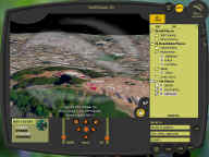
Figure 1
|
The application consists of a single large window with a "sculpted",
non-rectangular frame (figure 1). There does not appear to be any
option to use a normal rectangular frame, or to dock, hide or re-arrange any
aspect of the user interface.
Paging and streaming of the data was very smooth and responsive over my DSL
line (1.5 Mbit/sec downstream) Cracks in the terrain elevation would
sometimes appear during paging, but these were minor.
3D navigation is always a difficult area, since there are no standard
interfaces, as there are with 2D GUIs. In 3D, what is intuitive for
one person can be entirely confusing and difficult to another.
EarthViewer 3D is no exception. I found the means of panning and
zooming to be very frustrating. The controls which make sense when you
are looking straight down cease to make sense when you tilt the camera.
At that point the controls labelled "up" and "down" actually move you
forward and backward (!) and to actually move the camera up or down involves
a series of back-and-forth "move, zoom, move, zoom" operations. After
a few minutes i started to adapt to it, but by no means was it intuitive.
"Turn" left and right does not turn the camera, but rather rotates it around
some arbitrary, unmarked point somewhere ahead of you. Similarly
"Tilt" does not simply pitch the camera, it rotates it around that
mysterious point. I could find no way to simply move the camera up or
down, or to turn or tilt it, which is quite a dramatic shortcoming for a 3D
viewer.
Keyhole has clearly arranged to license some very large and decent quality
commercial datasets.
Imagery
The low-resolution full-earth coverage, presumably the 1 km earth image
EarthSat (see Whole Earth
Imagery) was very poor; Keyhole would probably do better simply using
the new NASA Blue Marble 1km image.
The color aerial insets for U.S. cities were beautiful - even stunning.
A few international cities were also present, although coverage is quite
spotty. For example, in Europe, there is Paris, central London, and
the western half of central Amsterdam - but not Berlin, Rome, etc.
The U.S. imagery outside of major cities, reportedly 15m resolution (from
Arc Science Simulations), is quite variable in quality. While some
areas are quite good, in others there are issues including wildly divergent
color calibration, very blurry areas obviously far rougher than 15m, and
some significant cloud coverage.
An impressive inset was Afghanistan, although it was marred by enormous
blue areas in the desert where there are no actual bodies of water.
Since similar artifacts also appear in this part of the world in the Blue
Marble imagery, i presume that this is a pitfall inherent in the source data
such as AVHRR.
Elevation
|
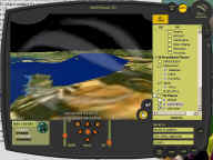
Figure 2
|
This is the weakest point of the dataset and the application as a whole.
The elevation is very, very low resolution - it appears to be far less than
the claimed 1 km. If there are any higher-resolution areas, i could
not find them. Furthermore, the elevation is very often badly
unaligned with the imagery, resulting in situations like figure 2, which
shows a strange, enormous blue mountain near Cape Town, South Africa.
Culture
There isn't any. Anyone expecting 3D models of major landmarks (as
in, e.g. Microsoft Flight Simulator) will be disappointed - everything in
this application is completely flat on the ground. In fact, the lack
of dimensional data combined with the incredibly-low-resolution elevation
provokes the question of whether "3D" even belongs in the product name.
The major drawback to relying on high-res imagery alone without any culture
is demonstrated by Figure 1 above, in which Coit Tower, a tall vertical
structure, appears to be bending until parallel to the ground!
Roads, Addresses, Businesses, Points of Interest
The geocoding and road databases worked well enough. In some cases
place names were up to several kilometers away from the feature they
described, but generally this feature was quite usable.
At this price point ($600), Keyhole is unlikely to attract a user base of
home users, geographers, hobbyists, terrain enthusiasts or virtual tourists.
It seems that their intended markets are more business-oriented, and by
focusing on the abstract data layers they may indeed find some customers in
specific vertical niches.
As for the numerous data and usability problems i encountered, the
application and datasets will surely improve with time. For example,
Keyhole could trivially add customization of the UI and a choice of
navigation metaphors.

