There are several ways to refer to a coordinate system. Some people casually refer to any coordinate system as a "projection", but this is not strictly true. "Geographic" coordinates, latitude and longitude, are in fact not considered "projected." Most coordinate systems used on the earth consist of two coordinates: these are generally called an "easting" and a "northing."
Some standards use the terms SRS (Spatial Reference System) or CRS (Coordinate Reference System) which encompasses both geographic and projected. CRS appears to be the increasingly popular choice, and it's a lot shorter to type than "coordinate system." If a CRS is geographic, it may be called a GCS; if projected, a PCS.
Some of the most common types of CRS you'll encounter are:
- Latitude-longitude ("Geographic")
- Universal Transverse Mercator (UTM).
Here's an explanation of UTM: Mercator, Transverse Mercator, and Universal Transverse Mercator.
You may also encounter the State Plane Coordinate Systems used exclusively in the USA.
Unlike local surveys, which treat the Earth as a plane, the precise determination of the latitude and longitude of points over a broad area must take into account the actual shape of the Earth. To achieve the precision necessary for accurate location, the Earth cannot be assumed to be a sphere. Rather, the Earth's shape more closely approximates an ellipsoid (oblate spheroid): flattened at the poles and bulging at the Equator. Thus the Earth's shape, when cut through its polar axis, approximates an ellipse.
A "Datum" is a standard representation of shape and offset for coordinates, which includes an ellipsoid and an origin. You must consider the Datum when working with geospatial data, since data with two different Datum will not line up. The difference can be as much as a kilometer!
Some USGS software uses a set of 25 different Datums and 20 Ellipsoids.
The GeoTIFF standard has around 120 Datums and 35 Ellipsoids, with 978 Projected Coordinate Systems.
These are defined by the EPSG, a group which publishes large tables of every projection convention.
While the difference between common datums (e.g. NAD27 and NAD83) is effectively a horizontal shift, some datums are defined for elevation, which is a vertical shift. In particular, there are two common kinds of vertical coordinate system:
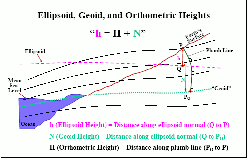
If you are working with GPS, it gets your 3D position from satellites, so it can easily give you ellipsoidal height, for example relative to the WGS84 ellipsoid. It is more difficult to convert that a value you are more likely to want, orthometric, which appears on your topo maps. That's because orthometric requires using a geoid, which is a complex, lumpy, large amount of data!
There is software for converting between vertical datums; some of it is free. Read to learn more: