Location: France
< back up to Europe
- The National Geographic Institute (IGN)
is the starting point for all data licensing, although their site is French
language only; i cannot tell exactly what digital data is available at what
cost.
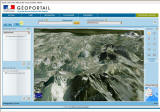
- In June 2006, IGN
announced their
Géoportail, a 2D/3D interface for browsing their entire data catalog.
- The data itself will be free for non-commercial use only in very rough
form (1:1,000,000), licensed commercially for better (1:25,000). There
is a
overview in French (pdf), and here is a machine translation into English:
IGN_France_GeoPortail_EN.pdf
- April 2, 2007 –A
press release says "The French 3D ‘Geoportail’, scheduled to open
to the general public in late summer 2007, will be based on the SkylineGlobe
Enterprise solution."
-
 August
1, 2007 - A beta of the 3D Géoportail is launched:
Découvrez le Géoportail en 3D. As expect, it uses
SkylineGlobe's TerraExplorer
IE plugin. The image and elevation quality looks very good, but as
the interface is entire in French it's not clear where the other stuff
is (place names, boundaries, etc.)
August
1, 2007 - A beta of the 3D Géoportail is launched:
Découvrez le Géoportail en 3D. As expect, it uses
SkylineGlobe's TerraExplorer
IE plugin. The image and elevation quality looks very good, but as
the interface is entire in French it's not clear where the other stuff
is (place names, boundaries, etc.)
- on the government site
Inventaire
Permanent du Littoral it is possible to freely download digital orthophoto
of the coast
- Mont Saint Michel
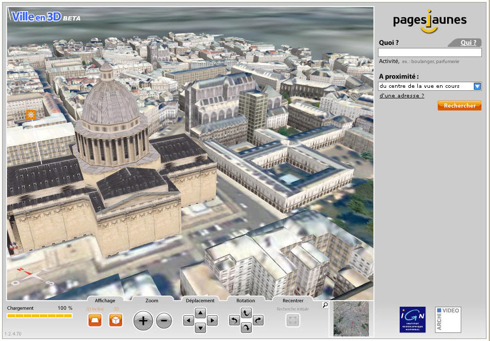
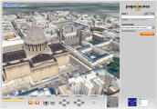
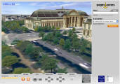
- PagesJaunes 'Ville en 3D' Beta
(2006-2007) by Archivideo
- Website with huge, beautiful detailed models of
Paris and
Rennes
- As of September 2006, it's definitely a 'Beta'. Unfortunately
they use the Shockwave viewer so the experience is rather constrained: fixed
window size and navigation speed, very close LOD distance and lots of flashing
and popping as things are paged. It also suffers from out of control
memory usage. When i tested it, it started at 330MB and 30% CPU at
start, increasing gradually to 100% of CPU and over 1.1 GB of RAM (!) even
when the browser was minimized. This brought my machine to a crawl.
- Aside from the viewer, the city models themselves are excellent.
There are complete textured building models for nearly every single building!
What software or process was used to produce such a massive, detailed dataset?
-
- On September 20, 2006 Archivideo provided some information:
- The model of Paris: "Data came from IGN (aerial photo like
on the GéoPortail, and not very detailed building footprints). About
80,000 single buildings have been automatically created with FastBuilder
(textured walls, and roof geometry). About 200,000 trees from different
sources created in 3D with FastBuilder. 30 significant buildings like
the Eiffel Tower."
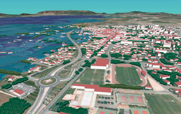
- The model of Rennes: "Data came from the city office (detailed
building footprints, DTM, DSM, aerial photo, position of trees). About
50,000 single buildings were automatically created with FastBuilder
(textured walls, and roof geometry). About 150,000 trees (textured cross
geometry) created with FastBuilder. 100 significant buildings were handmade
with a standard 3D modeler (e.g. 3DS Max)."
- See more about Archivideo on
City Modelling: Consulting
and Services
- Territoire3D (2012), co-production
of Archivideo and
IGN
- The site's entirely in French, so i can't tell if it's a publicly viewable
or not, but the screenshots show a very attractive 3D model of all of France.
Presumably this is a much updated version of the "Ville
en 3D" effort from 6 years before. Perhaps this is a commercial
product? There is a link to "register to test" it.
- Montbéliard
- CyberCity AG has a commercial 3D model of Paris, most significantly including
building models.
- As of 2008, they are called CyberCity
3D and they were a collaborative partner with Google in their "Cities
in 3D" program
- Rhône Valley
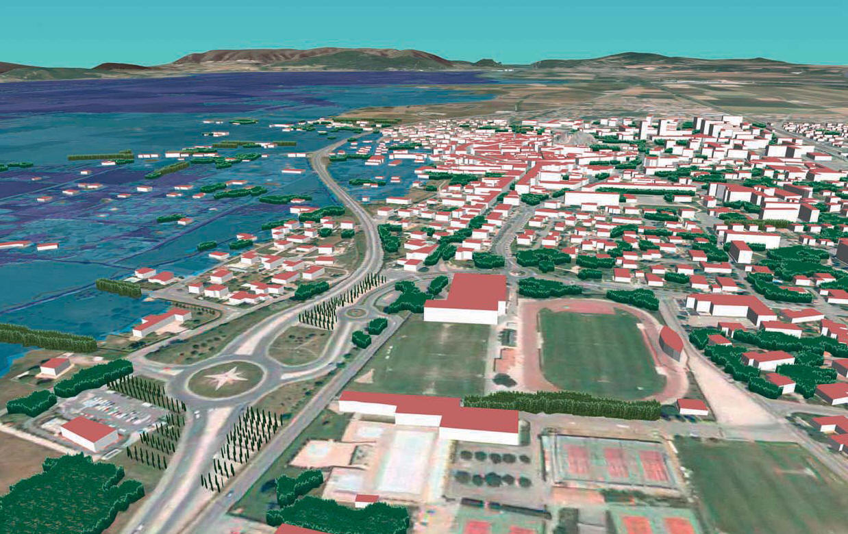
-
September-October 2009 IGN Magazine (French language) has a long article
on a project to use LIDAR and simulation to predict flooding, with 3D views
by Mme Florence Jacquinod using the VTP software:
- July 2, 2006: BBC article
Test
driving a cityscape describes some virtual terrain projects in France
- Cannes: "A 3D mock-up was commissioned by the city
so planners could peer into the future and see how developments will affect
the chic resort's delicate balance."
- Centre for Building Technology (CSTB) has done
3D lighting studies of Place du Bouffay in Nantes, and bridges in Paris.