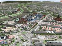
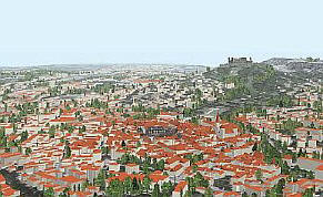
- Australia-based survey company uses advanced photogrammetry (apparently only imagery, not LIDAR) to make very detailed models. Roofs looks flat, straight lines are straight, even trees look reasonable.
- Impressive demo video, October 2012:
- Launched 2011, their main technology is turning photographs into 3D models. A major use case is to turn aerials into building/city models.
- They market a "Surveyor Edition" which "can handle up to 1,500 photographs without any limitation in size, and allows computations to be parallelized on a cluster of 3D reconstruction engine", and an even larger-scale "Mapper Edition".
- It's not clear whether they actually sell software, or prefer to provide services.
- In November 2012, they made an "OEM" partnership with Skyline.
- Includes PopArchitexture, Concept 3D, Estate 3D, Luna Tech Designs, as well as some of the large service companies below.
- Generally, they start at around $100 for a basic building.
- Services available to municipalities for "creating, managing and using digital 3D city models"
- Services include 3D laser scanning (mobile mapping), organization of aerial photos, processing of roofscapes, façades and street plan, underground installations and tunnels, structural engineering and excavation projects
- They use a suite of in-house software (CityGRID Modeler, Manager, Planner, Explorer, Scanner, Ortho) which interoperates with ESRI products for a GIS connection
- CityGRID Explorer is the VRML-based interactive 3D module (not freely
distributed)
- Builds "PC-based high-resolution urban simulation VR models for a wide variety of architecture and planning applications" with their own proprietary run-time, SimView
- They have done a number of projects in the state of Michigan, USA, where they are located
- Offers a rapid city modelling service, at a typical cost of $150k per km2
- "A full spectrum of core capabilities and custom solutions for
urban infrastructure, tourism and travel, real estate, security and defense,
3D yellow pages, entertainment, media and advertising applications"

- They created the Virtual Philadelphia site/app (see US: Pennsylvania for more)
- In addition to processing an analysis of aerial photos, they list examples of 8 German cities they have modelled
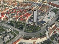
- Detailed DTM, and hand-textured buildings with multiple LODs
- They use their own advanced photogrammetry software tridicon which includes rapid, efficient, high automated extraction of 3D buildings
-
- Includes a runtime visualization component called CityDiscoverer which is built on the VTP software
- One of the very first companies to focus on 3D urban modeling in the 1990s, they have helped coordinate the development of many "virtual cities" in 3D Studio MAX and VRML
- Most of them use a single very low resolution ground texture combined with simple extruded building outlines for a small number of downtown buildings
- Cities include: Atlanta, Austin, Baltimore, Boston, Chicago, Denver, Lake Tahoe, Las Vegas, London, New Orleans, New York, Portland, San Diego, Sydney, Tokyo, Vancouver
 Archivideo
(public site in French only)
Archivideo
(public site in French only)- Their in-house proprietary software is called FastBuilder. It does "automatic modeling of complex territories from heterogeneous spatial data". They have been developing FastBuilder for more than 7 years. It is especially designed to generate 3D models automatically from IGN data (the French National Geographic Institute).
- The models can be viewer in a webpage using Shockwave, or as a stand-alone application (built on OSG/Qt).
- Their showcase models are Paris and Rennes, as describe on the Virtual France page
- Typical fields of use include 'landscape, town planning, architecture, infrastructure'
- Their partners are entirely French.
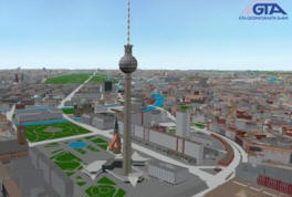
- Partnered with 3D Geo, they use 3D Geo's LandXplorer software suite to provide city-modelling services, and to deliver solutions based on those models
- They are 'the recognized system integration partner for LandXplorer products.'
- Examples of cities they have modelled in Germany (Berlin, Chemnitz, Dresden, Leipzig) and Akron, Ohio in the USA, a highway in Italy, and several other urban planning and transportation projects
-