Location: California
< back up to USA
State of California - General Notes
- Cal-Atlas
is the state GIS site, with lots of data. (t was previously called
CaSIL - California Spatial Information Library)
- Elevation Data
- from the the CSU Northridge Department of Geography:
- Vegetation
- DRG
- DOQ
- California Digital Library
(CDL): ADL Web Client
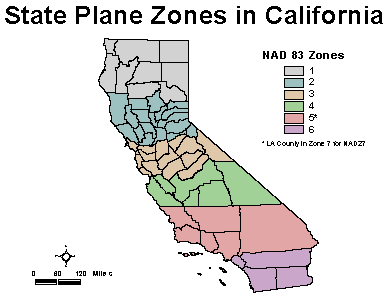
- California State Plane Coordinates
- a commonly used coordinate system
- it is divided into 6 zones, along county boundaries
- the map to the left shows the division
[source]
- city of Brentwood
has street/parcel map data browsable online
- USGS Lake Tahoe Data Clearinghouse
- California Coastal Records
Project, an aerial photographic survey of the entire California Coastline.
- OpenTopography
Portal
- provides high resolution LiDAR topographic data along major active
faults, mostly in California
- these are generally gridded into 1km tiles, at 50cm resolution, in ArcInfo
format
- the data is recent (e.g. 2003-2007) and provided in both raw and bare-earth,
but the vertical values are "heights above the ellipsoid (WGS84)" which
doesn't correspond with most other's data value for sea level
San Francisco Bay Area
- Data
- Bay Area Mapping Association: BAAMA
- non-profit, professional organization that organizes bi-monthly educational
forums, the annual California GIS Conference, and periodic technical tours
on a broad range of geographic information systems (GIS) and automated mapping
topics including:
- regional data sharing, metadata, guidelines and standards for digital
data
- photogrammetry, web-based GIS, wireless GIS
- San Francisco Urban Forest Mapping
Project
- First released in 2007, digitally pinpoints the location of each
tree, maintains tree data in a consistent database, and offers web
access to the tree data
- As of 2011, the platform and database is
OpenTreeMap,
and it can export tree information as KML or CSV
- the S.F. Bike Map project
(now defunct)
- was a Java application for finding the optimal bicycling route between
the hills of San Francisco, with route directions, route maps, and an address
finder
- it would be great to do this sort of app in 3D, especially in places
like SF where slope is a major factor
- the story from author Trevor Smith, as of 03.07.23:
"The SF bike map project was originally going to a
web application as part of the San Francisco
Bike Coalition web site but during the shuffle of leadership over there
they lost interest in it. So, I packaged up the renderer and route
finder into an executable jar. It works, but isn't the prettiest UI
you've ever seen. There's a
sourceforge project
where you can get the source and the executable jar. The map data
that is in the repository is just the US Census TigerLine data combined
with the USGS elevation maps for San Francisco. It could do with some work,
too."
- there was an existing product: Virtual San Francisco (see
Virtual Tourism) which produced 3D models of a
large number of SF buildings, but the company went out of business in 2003
- "3D San Francisco"
- Release January 2012, it is basically just a series of placemarks in
a website surrounding the Google Earth web plugin. It works well enough
to guide the user around to a number of the prominent hotels and sights.
Palo Alto
-
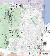 The
City of Palo Alto
The
City of Palo Alto
- GIS Data
- there is a "citywide GIS Technical Advisory Committee" mentioned in
this
City Manager Report, but otherwise very little about GIS on the city
website
- a San Francisco company called Geodesy has been "instrumental in
the development of the city's GIS applications" and has a contract to
further integrate the city's GIS, Utilities CIS, and CADD projects.
- their data is maintained as "OGIS compliant standard blobs in a relational
database" by "Encompass", which is a set of ActiveX components created by
Geodesy
- the blobs can be translated to GeoMedia or ESRI formats, but those formats
do not allow for the complete storage of all of the information
- conversion to ESRI SHP files on 02.01.09, resulting in:
- Built Features, 3 layers
- blb_3.shp should be importable into VTBuilder as building footprints
- Road Features, 26 layers
- Transport Centerline, 4 layers
- tcrd_2.shp should be importable into VTBuilder as road centerlines
- coordinate system is California State Plane (zone 3)
- coordinate problem: CA Zone 3 meters
vs. feet
- Palo Alto was the site
for a PRT study by Cities21 which would
leverage the VTP for visualization
VTP Demo Area in 1999: Santa Clara, California
-
 acquired
USGS 30m DEMs, free download from BARD
(Bay Area Regional Database)
acquired
USGS 30m DEMs, free download from BARD
(Bay Area Regional Database)
- a BT was extracted using VTBuilder
- a road map for the city of Santa Clara was created using
VTBuilder from USGS DLG files
(milpitas, sanjose-west)
- VTBuilder was also used
to correct the number of lanes and set the direction of traffic flow for each
road segment, which is used by Enviro to display proper road striping
- a corporate headquarters was modelled in 3DS MAX and brought into Enviro
- vehicles were added to the roads, using a simple network-traversal algorithm
for autonomous
Southern California
-
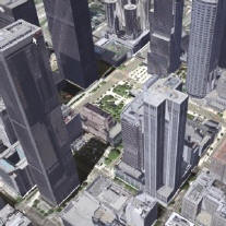 the
UCLA UST (Urban Simulation Team) has
modelled many parts of
Los Angeles
the
UCLA UST (Urban Simulation Team) has
modelled many parts of
Los Angeles
- downtown, the Pico Union district, El Pueblo, Mid-Wilshire, Wilshire-"Miracle
Mile", LAX, Westwood, UCLA, Hollywood Blvd. and Vine St., MacArthur Park,
Playa Vista, and a portion of South Central.
- CyberCity AG has a commercial
3D model of Los Angeles
- includes many datasets, including ground-level textured model, auto-textured
building models from stereo aerial photos, true ortho-photos, and a 1m DTM
- Mojave Desert Ecosystem Program
is a GIS Data Clearinghouse which has:
- DOQQ and 100k DRG in TIF format, DEM in E00 format
- 100k vector data: boundaries, hydrology, transportation, vegetation
in E00 format
- 30m Landsat5 from 1993, which appears to be neither color-corrected
nor georeferenced?
- in BIL format
- really large files (>300 MB)
- Lenska Aerial Images is a major
regional imagery vendor
Historical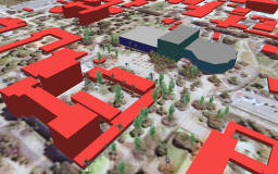
- Santa Barbara
- In 2001-2004, Dan Ancona was at UCSB
working on connecting the VTP to the Alexandria Project, and part of the work
included a model of UCSB
- ADEPT DE development
plan - near-term objectives are to create a detailed, navigable in real-time
model of the South Coast region (defined as approximately Point Conception to
Carpinteria)
- AIS Terrain Team (later became AIS)
created a model of
Los Angeles in 2000-2004, meant for use in police/military training and
simulation
