Distribution of Plants on Terrain
Possible ways to describe plant distribution
- Raster: Using a coverage bitmap
- discretely - type information per element of the elevation grid, or
any overlapping grid
- pro: easy to draw in a paint program, easy to vary density
- con: doesn't work well for fine boundaries, e.g. along the edge of a
road
- Polygons
- structured - polygonal bounding regions indicate areas of plant
coverage
- pro: more precise placement, works well for crops
- con: would have to create graphical tool for defining the areas, or
rely entirely on existing polygonal data sources
- Points: Placing individual trees, or lines of trees
(e.g. along a road or fence)
Producing plant distributions
Sources of Data
- The
GlobeLand30
(GLC30) LULC Dataset
- has 30m coverage
globally, released 2014 by
China's National Administration of Surveying, Mapping and Geoinformation
(NASG)
- apparently it is online, browsable and
downloadable at
globallandcover.com
- "ten major land cover classes": Water bodies,
Wetland, Artificial Surfaces, Tundra, Permanent snow and ice, Grass
lands, Barren lands, Cultivated land, Shrub lands, Forests
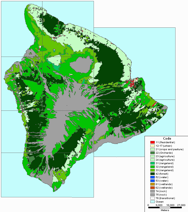
- USGS LULC (land use
and land cover) files (see below)
- includes classification code such as "Herbaceous Rangeland" and
"Evergreen Forest Land" which very roughly description vegetation type
- U.S. only
-
 USGS
Global Land Cover
Characterization
USGS
Global Land Cover
Characterization
- huge raster files, in a raw format, with 1km coverage of the whole
earth
- has much better classification than LULC, example of a single type:
"Needleleaf Forest (Western Hemlock, Sitka Spruce, Douglas Fir)"
- the main drawback is the very low resolution (1km) which makes it
useless for visualization at a human scale
- European Space Agency (ESA) Ionia
GlobCover
- GlobCover Land Cover V2.3 (Dec. 2010) is the highest resolution (300
meters) Global Land Cover product ever produced. Based on
ENVISAT MERIS data at full resolution covering 2 periods: December 2004
- June 2006 and January - December 2009.
Labeled according to the UN Land Cover Classification System.
- Version 2 was a
436 MB GeoTIFF file.
- The GLCF has global
vegetation data
- USGS NLCD
(National Land Cover Database)
- WWF
Ecoregions
is an amazing global map of ecoregions
- the map data is available (25 MB zipped Shapefile), only requires
submitting an email address
- USDA vegetation maps? 7.5-Minute DLG Vegetation Overlay?
- a great many people in the GIS field use
polygonal areas with attributes (e.g. in a Shapefile) to describe vegetation
coverage
- unfortunately, there are no standards for the number and meaning of
the attributes
- therefore, there is almost never a consistent way to exploit these data sources,
or to exchange data

- OpenTreeMap
- A set of web software (built on Geoserver, Django, PostGIS, etc.)
which provides a front-end to a GIS dataset of individual trees in a
city, in use in San Francisco and Philadelphia as of 2011
- Has a standard set of attributes per tree, including species
name, location, height
- Can export tree lists as KML or CSV files.
Polygonal Data Formats
- Standard GIS formats (ESRI Shape,
MapInfo...) are commonly used to represent polygonal data. However,
there are no standards at all for the per-polygon attributes that go along
with these datasets, so importing data (e.g. with
VTBuilder) requires a manual step
of mapping one set of attributes onto another.
- Example of polygonal data with attributes: the
GIS Data at the Charles Lathrop Pack Forest
- a good, free, detailed dataset includes polygonal coverages for soil,
lakes, and forest stands
- There are some domain-specific polygon data formats, such as USGS LULC, which define a
standard for their attributes and can therefore be understood directly by
software.
USGS
LULC (land use / land cover) files
- 37 land usage types
- detailed description of each classification code is described in:
Anderson, J.R., Hardy, E.E., Roach, J.T., and Witmer, R.E.,
1976, A land
use and land cover classification system for use with remotely
sensed data: USGS Professional Paper 964, 28 p.
- LULC does not contain any information about species or
ecosystem, so it's primary usefulness is to describe vegetation
density
- for example, it can tell which areas are agricultural, but not which
crop is growing there
- the 1:100,000-scale format is a 30' x 60' quadrangle, UTM-based
- can be read by VTBuilder
and the the vtdata library
- it turns out GIRAS (the underlying format of LULC) is not
difficult to read
- however, the map coordinates are in a strange format, "local UTM"
- how to correctly convert these coordinates to lat-lon or
actual UTM is unclear
- one way is to use the four LULC corners as a guide, defining a
"perspective transform"
- format description
- As of 2010, classic polygonal LULC is out of favor; most landcover
data is now in raster form which is more efficient for high detail and
more directly output from remote sensing classification.
 General Land Cover Classification
-
Besides
placing vegetation, land use/cover classification like "pasture" or
"pavement" can be use to generate synthetic
Geotypical, Ground Cover Texture or
Detail Textures.
- Many software tools exist to classify space/aerial imagery
-
Feature Analyst
($1k-$16k depending on license type, ArcGIS plug-in)
- MaterialMAP
from TerraSim ($?) is specifically for the Vis-Sim field (output for
VBS2, Steel Beasts, OneSAF OTF, and JSAF CTDB)
Classification of Vegetation
- there is very little standardization
- some people treat classification of vegetation as a subset of general
land-use classification (e.g. the USGS and USDA) but this does not well
describe either the physical appearance or the scientific
description, e.g. species
- one fairly common physical measure of trees in the forestry industry is
their radius
- "There are some standards, but surprisingly few, and almost always
non-visual. Some ecologists have worked on structural vegetation
classifications, since it turns out that structure is very important to
birds, for instance. But from what I've seen, this is usually for trees
only, mostly based on age, "site class" (soils/slope/aspect), and
DBH. I've
never seen anything which would cross-walk a meadow from Siberia to Florida.
You might get part of the way there with a structural description of
vegetation form ranges (bounding sphere x age?), plus geographic range (by
bioregion?). You could then pick the closest vegetation form from the
closest broad bioregion. If you are in a forest in the NE but have no trees
for that area, fallback might be trees of same size from a Michigan forest."
- Michael Flaxman of Geodesign
Descriptions of Plant Distribution
Game Programming:
- "We simply have the artists create a density map for the terrain and
then randomly (with a seed) place/ render vegetation depending on the
density map. Then between min and max distance we either shrink objects to
size 0 or fade them out using alpha. This approach works fine for small
stuff like grass or ferns." - Daniel Vogel, Epic Games